
Today's fun new feature is a colored visited-airport map. I'm calling it "Beta" for a few reasons I'll discuss below, but it works pretty well.
The idea is to color in countries* and (a limited number of) states/provinces in which you have recorded flights.
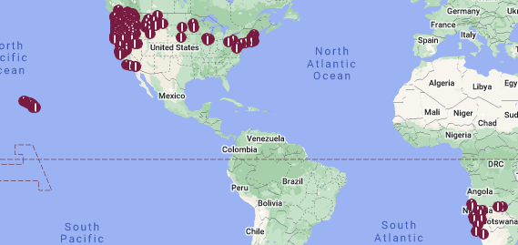
Here's mine:

This, of course, looks very similar to the Visited Airport map I've had for a long time that is based on Google Maps:
To try it out, go to Airports->Visited Airports->Countries/Regions and click "View a colored map of visited countries/regions/sub-regions (BETA)" to view your map. This link is sensitive to any query you've done on the Visited Airports page, so if you change your search criteria there, it will change in the map as well.
The colored map has some fun features:
- You can turn the airport icons on/off (check/uncheck the "Facility" checkbox)
- You can drag the map around and zoom it
- You can see new places you visited by year (look in the right-hand bar) and even animate your visits over time using the play/pause bar on the bottom of the screen.
- You can hover over a top-level region to see its details, and click on it to view the airports in that top-level region.
- Click on an airport icon to view the name of the airport and the year you first visited it.
- In the upper left corner, you can see the number of top-level regions, subregions (states/provinces/etc.), and airports. Click on these to see details.
But it also has a few limitations.
One is that the map it's based on is only coded with some states/provinces/subregions, so for now at least it will color in countries and then will add a darker color for states/provinces in the US, Canada, Australia, South Africa, Brazil, and Germany. That's probably OK, since outside of these countries, most of MyFlightbook's sub-regions are small - more akin to counties, which only have a few airports each, so the coloring is less interesting.
Another limitation is that while you can zoom and drag the image around, you can't "rotate" the global projection to put your particular region in a central top-down view.
The code I am integrating also assumes a full document window, and I haven't done the engineering to put it into a "MyFlightbook" skin, so I'm opening this into a new window/tab so that you don't lose where you were in MyFlightbook.
Let me know what you think!
*As I disclaim on the Visited Airports page, I'm distinguishing "countries" from "nations." This is meant to be a fun feature, and I am not making any statement about political divisions, only major geographic regions. E.g., Greenland is a territory of Denmark, but is treated as a top-level region in this taxonomy.
No comments:
Post a Comment